At Eslan Labs we have long recognized the importance of flexibility provided to our clients by our use of open GIS

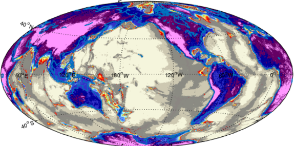
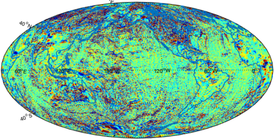
Source is our GIS geoscience platform, created to help our partner clients in their frontier and new ventures exploration. Source can be integrated with in-house data, and Eslan Labs’s will help with each step in the process. Source is driven by our global compilations of gravity and magnetic data and quality geoscience sources, research publications and Eslan’s own structural analytics and delivers modern tectonic, plate, and structural.

All data used in generating our interpretations are stored using open GIS management systems and collaborative open-source tools. We use cloud hosted GIS databases where the data are encrypted at rest and on the move. These databases include attributes and metadata that provides information on what the data contains, detailed descriptions and explanation of attribute tables and examples of how the data was used. All of Eslan Labs’ open GIS feature classes include comprehensive attribution, reflecting data confidence and provenance.

After many years experience, we avoid proprietary commercial geophysical data processing systems, because most use proprietary storage formats trapping data in that system.  Our open GIS spatial databases are all provided in open industry standards: WMS, Shapefiles, PostGIS, and so on which ensures that our data is available in industry-standard formats that are compatible with virtually all GIS solutions adopted by our clients.

Our geological interpretations are based upon a set of data layers including gravity and magnetics grids and their various derivatives, remote sensing imagery, DEM, published and geo-referenced images from literature, and geological maps.

All of the data layers are stored as feature classes or raster datasets within an enterprise Open GIS database which in our lab is Post GIS. Importing these open GIS databases into any commercial GIS is simple. These data are fully managed to ensure data consistency, accuracy and  attribution.

Our open GIS teams are also experts in Matlab, Python scripting and JAVA, in order to adapt our open workflows to meet our clients requirements.

Global gravity

Gridded Bouguer Gravity databases at 1 and 2 arc minutes resolution

global TMI

Gridded Total Magnetic Field Intensity databases at 1 and 2 arc minutes resolution

Gravity and Magnetics

Including all of Eslan Labs’s reprocessed Gravity and Magnetic databases from around the world. These are fundamental to the interpretation of structural and tectonic elements, and crustal architecture.

Tops Database

This database comprises data for over 10,000 point locations around the world and includes stratigraphic ‘tops’ in wells, outcrops and pseudo-points. These also encompass 1D modelling points and additional sedimentological, petrological, geochemical and palaeontological data qualifying the broader definitions of the underlying polygons in ShapeFile formats.

Open GIS Databases

Our Open GIS allows the Eslan Labs geoscientists to generate detailed crustal architectures, structures, geometries of sedimentary basins, basement architectures, regional depositional environments, and more. All of these are spatially linked, and the generated datasets form an integral part of Eslan Labs foundational geology database.

All of the data layers are stored as feature classes or raster datasets within an enterprise Open GIS database which in our lab is Post GIS. Importing these open GIS databases into any commercial GIS is simple. These data are fully managed to ensure data consistency, accuracy and  attribution.

There are more than 8,000 line locations in Eslan Labs’s database which include seismic, well-correlations, structural cross-sections and chronostratigraphy charts. The location lines are used to help with the extents of lithologies and depositional environments; they are also used by tour structural experts to aid in their interpretation and analysis of the structures.

Remote Sensing Databases

Landsat data has long been publically available, but the skills to interpret this data correctly are highly specialized. Much of Eslan Labs’ onshore geological work in Africa has been based on analysis of Landsat and other remote sensing datasets. The radar-derived DEM data, SRTM30, SRTM3 and SRTM15 have been analysed as part of Eslan Labs’ extensive experience in Landscape and Drainage Analysis and reconstuction.

Surface Geology

Geological maps are used as a first pass to create the digital geology feature class. These are then modified with Eslan Labs’ in-house data (bathymetry, SRTM3, gravity and magnetic derivatives, and our structural dataset) to provide a robust solution for surface geology.

Technical Reference Database

Eslan Labs have our own in-house Referencing database with tens of thousands of references. We check each reference for useful geological information as it comes in so that it can be continually added to the reference data layers.

open gis fused published map data