Magnetic targets located anywhere other than at the magnetic poles are asymmetrical, distorted by both the Earth field’s inclination and declination.The lower the magnetic latitude, the more complicated the anomalies.
Reduction to pole (RTP) produces a map that is more closely related to the rock magnetization (and therefore geology) than is the total magnetic intensity (TMI), and importantly locates anomalies directly above their sources.
Ignoring such variation in the earth’s magnetic field across large regions can lead to inaccuracies in anomaly location and in source-body geometry.
Without reduction to the pole (RTP), magnetic anomalies can be shifted by several kilometers
The earth’s magnetic declination and inclination don’t change in a fixed way across a set distance or a set change in latitude or longitude.There are several approaches to handling this problem for reduction to pole.
Standard Reduction to pole (RTP)
Standard reduction to pole (RTP) practice assumes that inclination and declination is identical for all the data points contained in the field. But things can go awry for larger areas, where the earth’s curvature becomes significant.
The standard reduction to pole (RTP) transform produces poor quality fields at low latitudes, often dominated by declination-parallel artifacts.
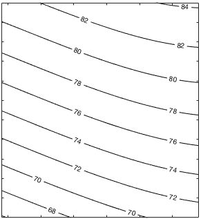
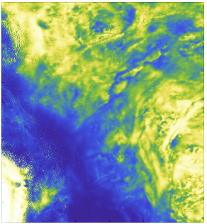
Magnetic inclination varies by more than 10 degrees over the region of 25×25 degrees in northern north America
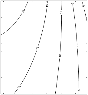
The study area’s magnetic inclination or the magnetic declination varies by more than 10 degrees in non-polar regions.
The operator can be implemented in two ways:
Frequency Domain: This reduction to pole (RTP) approach is fast and cheap but can only be applied to relatively small regions where inclination and declination remain constant.
Spatial Domain: This reduction to pole is computed in the frequency domain for each inclination and declination of the magnetic field the inverse spatial transform is convolved with the observed magnetic field.
Inaccuracy creeps into this reduction to pole approach because the reduction to pole RTP operator is truncated.
Differential RTP
A far superior method for reduction to pole is to apply the perturbations in the space domain using a Taylor series expansion.
Eslan Labs performs such a differential reduction to pole RTP where either the study area’s magnetic inclination or the magnetic declination varies by more than 10 degrees in non-polar regions.A standard RTP is applied with mean values of inclination and declination. At each location, a Taylor series expansion correction is applied to the mean RTP.
Inaccuracies such as these may lead to lease selections that don’t capture 100% of a causative body.
Erroneous RTP practice assuming that inclination and declination is identical across the field.
A far superior method is to apply the perturbations in the space domain using a Taylor series expansion.
Inaccuracies may lead to target selections that don’t capture 100% of a causative body.
Pseudo-gravity
After the differential reduction to the pole dataset has been computed it is simple to convert to pseudo-gravity by vertical integration and a scale factor.This is a useful technique for the interpretation of regional magneto-tectonic provinces since it simplifies anomaly patterns and focuses on large-scale features rather than local detail.
3D Analytic Signal
In the past, the analytic signal amplitude has been used to identify magnetic anomalies, since the analytic signal is a function of magnetic gradients and is easy to compute. However, the analytic signal amplitude lacks the resolution and the structural and pattern information of TMI and reduction to pole (RTP) field transforms.
The regional gravity anomaly field, can be compared directly with the pseudo-gravity field.
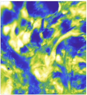
Large areas of low-amplitude and rugose magnetic patterns are characteristic of granitoid–gneiss terrains. These areas are separated by narrow, high-amplitude linear and curvilinear anomalies, representing complexly folded and faulted greenstone belts